Downtown Fairbanks Tunnels

A Wraiths-style photo (apologies to Jester) of the entrance.
Downtown Fairbanks has it's own steam tunnel "utilidor" system, which
runs under several block in the center of the city. The city gets its heat
and power from the GVEA coal-fired powerplant on the Chena River, and large
buried steam pipes run from this plant to the point where the tunnels begin.
The tunnels themselves are square concrete, probably pre-cast
sections, about 8x8ft. Every block there is a large junction / 4-way intersection
where the pipes and wires dive down under a steel walkway and meet at valves
on a lower level. The system was intended to be much more extensive than
it currently is, so most of the 4-way junctions don't actually have tunnels
leading off from every direction (merely provisions for future tunnels).
However, there is a place where the tunnels intersect an old section of
utilidor, about 5ft high and constructed from cinderblocks, bricks, and
concrete. This tunnel follows the main street north to the river, and south
to just past the old city hall and museum. some side tunnels
lead off to dead ends and what may have been building entrances, and manholes
lead out onto the street (this was my first experience with being under
a manhole when a car ran over it, which is an interesting experience).
The tunnel may continue to the south, as there are manholes farther down
that steam in the winter, but the fact that steam pipes enter and exit
this tunnel, and bisect it without actually following it, means that the
rest of the heating system is probably just buried pipes. It could also
continue north of the river, the original power plant was a few blocks
to the north on the far side.

The first junction we came to was one of the "partial" ones, set up
for additional tunnel connections but with only two tunnels leading off
it.

Another junction. These were a pretty standard design, some had manholes
in the center of the ceiling leading into the middle of intersections,
and some had side tunnels leading to sidewalk hatches.


Some exit tunnels and a sidewalk hatch. The hatches had alarm sensors
and some had phones to check in with the power company before setting off
the alarm.


Some nice shots of a 4-way junction (the only "full" 4-way)


More utility stuff. The corrugated pipes in the first picture are for
future building connections, we didn't find any buildings with direct,
accessible connections to the tunnels. The 4th picture shows one of the
maps located at junctions, these were somewhat useful but were way off
scale and didn't show some of the side passages or the old section of tunnels.

We were hoping this was a map of more of the system, but it's apparently
just part of the water system and shows buried pips along with pipes in
the tunnels.

Dajur investigates a pipe leading out to one of the sidewalk periscope
vents.

A flooded junction room. We were hoping for a storm drain connection
somewhere but didnt' find it.

Down at the end of the southern branch, the steam lines don't extend
this far for some reason.
The old tunnel appears to have been bisected by the east-west section of the new ones, a junction room at that point routes some utilities into the northern branch but very few into the southern (first photo below). As near as I can tell, this section could date back as far as 1938, when the original power plant was built on the north side of the river.


The old section at first appeared to be an emergency exit tunnel from the main system, since there weren't many pipes going in. Farther down the south branch some pipes enter from the sides and follow the tunnel for a ways, and this part has lights and location signs (3rd pic). The northern branch has fewer pipes and more power and communication wires (4th and 5th pictures, this was when Dajur told me to stop taking pictures of his ass).


These parts sucked. Way too much stuff crammed into an already painfully
low tunnel, and to add to the fun some pipes were cold, some were scalding
hot, and some of the cables were stripped of insulation.


The north end (first picture) south end (middle) and a typical square
manhole out of the old tunnel. One of these manholes had a gap that we
could look out of and see people at a crosswalk.
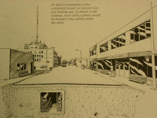
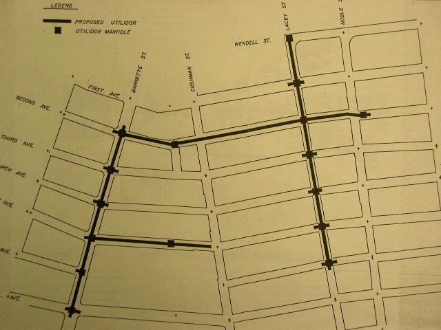
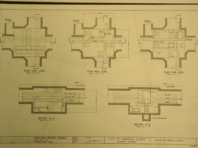
Three pages from a project proposal document found at the library.
Both the map and intersection diagram are inaccurate to some extent.
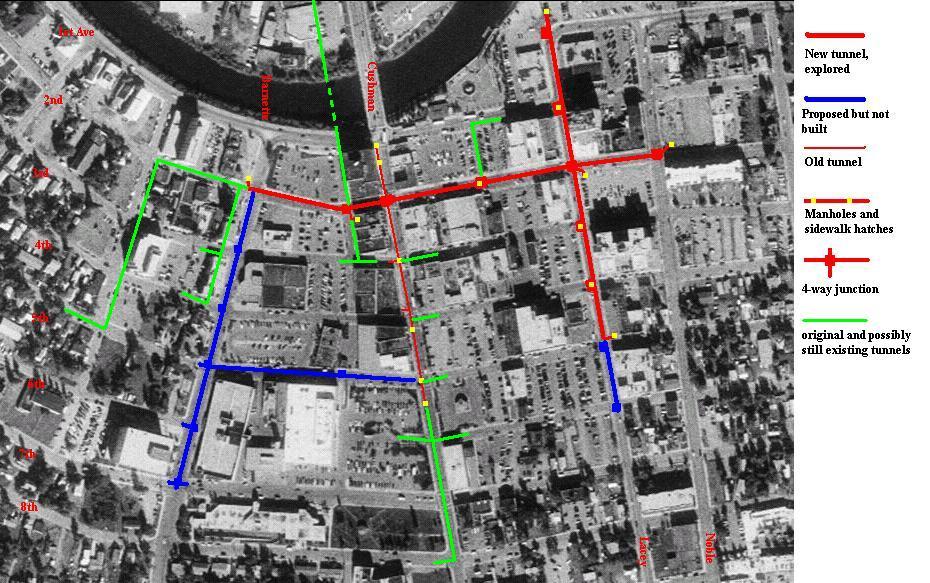
My map of the system, including proposed sections shown on the above
map.